THE SOUTH CHINA SEA FISHERIES REFUGIA INITIATIVE
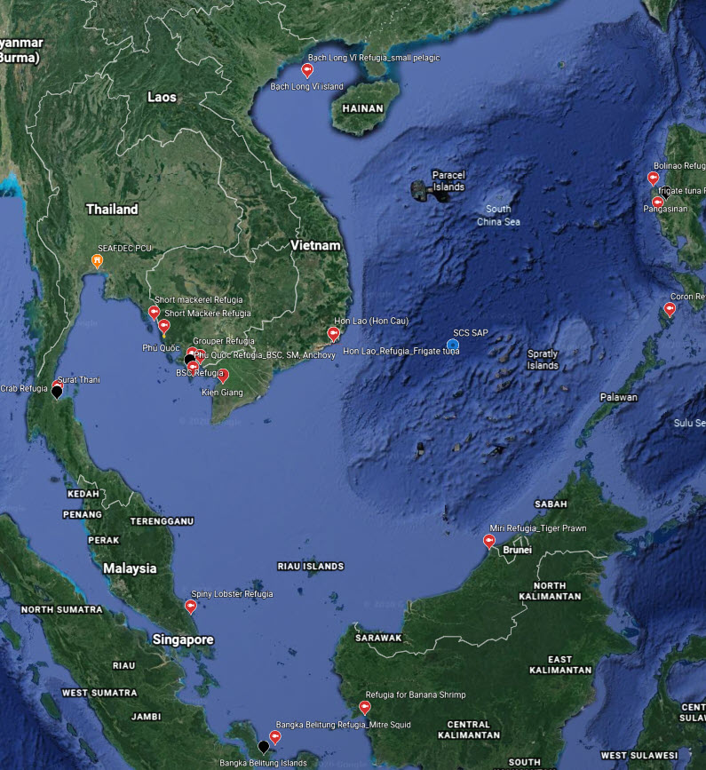
FISHERIES REFUGIA PROJECT SITES
 Click Here for
 More
Information
SCS SAP PRIORITY SITES (Habitat Linkages)
All SCS SAP and Fisheries Refugia
Priority Sites CHINA HABITAT
SITES CAMBODIA HABITAT
SITES INDONESIA HABITAT
SITES PHILIPPINES HABITAT
SITES THAILAND HABITAT
SITES VIET NAM HABITAT
SITES
Meet our Stakeholders
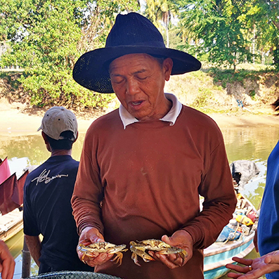
Mr. Viroj Buakleang
Crab Net
Prachuap Khiri Khan, Thailand
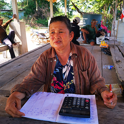
Mrs. Jamrat Buakleang
Crab consolidator
Prachuap Khiri Khan, Thailand
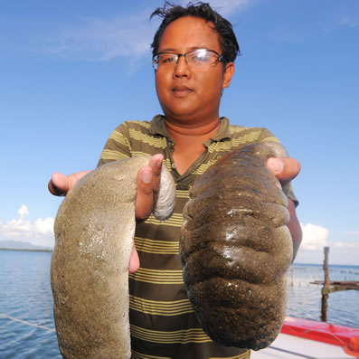
Mr. Jia Hao
Sea cucumber fisherman
Sabah, Malaysia

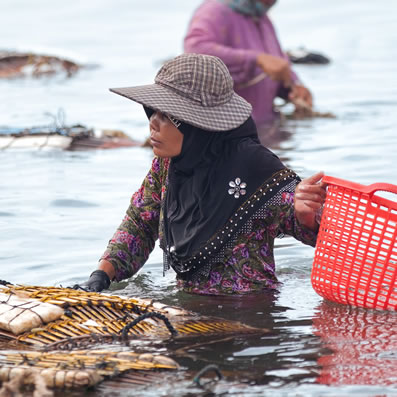
Ms. Ming Li
Fisherwoman
Sarawak, Malaysia

Mr. Somluck Polmoltri
Fish market vendor
Trat, Thailand
Ms. Srey Chey
Blue crab harvester
Kep, Cambodia
Social Media
Social Media
APPLYING THE OCEAN FORECASTING SYSTEM TO FISHERIES REFUGIA IMPLEMENTATION
GEF-UNEP/SEAFDEC Fisheries Refugia Project
Acknowledgment to the
“Thailand-China Joint Laboratory for Climate and Marine Ecosystem” and Phuket Marine
Biological Center/Thailand
This paper was introduced by Ms. Nuttida Chanthasiri, Researcher of Thailand-China Joint Laboratory for Climate and Marine Ecosystem, from Phuket Marine Biological Center at the 2nd Meeting of the Regional Scientific and Technical Committee of the SEAFDEC-UNEP-GEF Project on the Establishment and Operation of a Regional System of Fisheries Refugia in the South China Sea and the Gulf of Thailand, held in May 2019 in Kampot, Cambodia. Before her presentation, Mr. Somboon Siriraksophon, Project Director pointed out the importance of ocean modeling to support the establishment and operation of fisheries refugia at national and regional levels. He acknowledged the IOC/WESTPAC and other institution partners that have a long history of working in oceanic data management and developing the modeling system, which could help in predicting the habitats and fisheries resources changes. For example, algal bloom, coral reef bleaching, predicting sea temperature increase, larval dispersal, predicting the oil spill, etc. He also concluded the 2nd Meeting of the Project Steering Committee held in MIRI, Malaysia, in November 2019 supported the idea to apply the IOC/WESTPAC ocean modeling system to the Fisheries Refugia Project.
1. Beginning of OFS on the platform of IOC/WESTPAC and officially launched in Thailand
Ocean Forecasting Demonstration System or OFDS was officially launched for the first time during the 8th IOC-WESTPAC Meeting in Bali, Indonesia in May 2010. The system was developed by the First Institute of Oceanography or FIO based on the wave-tide-circulation model. In Phase-I of the project in 2010-2012, the first version of OFS covers only the southern South China Sea and was operated by Dr.Wendy Watson-Wright, Executive Secretary of IOC, Assistant Director-General of UNESCO. Then, the system has provided ocean forecast through the website: http://221.0.186.5/IOC_WESTPAC/OFS beginning since the 9th Intergovernmental Session of the IOC/WESTPAC on 9-12 May 2012, in Busan, the Republic of Korea.
During Phase II in 2013-2015, the domain was exยended to cover the entire Southeast Asian area including the northwest Pacific, South China Sea, and the northeastern Indian Ocean. The breakthrough of the OFS happened on 9 October 2013 when Chinese Premier Keqiang Li proposed to initiate the China-ASEAN Cooperation Fund and announced to subsidize the first 17 projects which included the OFS in the 16th China-ASEAN Summit. Later in 2014, the Department of Marine and Coastal Resources or DMCR has got the budget for setting up the OFS system in Thailand, and Dr.Wijarn Simachaya, the Permanent Secretary of Ministry of Natural Resources and Environment, Thailand, and Mr.Chen Lianzeng, Deputy Administrator of State Oceanic Administration or SOA, presided over the opening ceremony of the project under joint research projects to name the project “Ocean Forecasting and Marine Disasters Mitigation System for Southeast Asia Seas” during the 4th Thailand-China Joint Committee Meeting on Marine Cooperation on 17 July 2015.
Since 2015, the DMCR in collaboration with the FIO installed the OFS system at Phuket Marine Biological Center or PMBC, Phuket, Thailand, and also organize workshops instructing the DMCR to operate the system routinely. This was considered an official launch of the OFS Thailand. Meanwhile, PMBC linked the OFS website, http://ofs.dmcr.go.th/thai land/result.jsp, to the Central Database System and Data Standard for Marine and Coastal Resources webpage, https://marinegiscenter.dmcr.go.th, to distribute the forecast product to the public. So far, more than five training courses have been organized in Qingdao, China, yearly in order to trains the DMCR colleagues and other scientists to analyze and interpret the data. Moreover, both parties have constantly conducted joint cruise observations both in the Gulf of Thailand, the Andaman Sea, as well as the Bay of Bengal to obtain observed data for validating the model and further updating it into high resolution. Presently, four buoys have been deployed in the Andaman Sea constantly giving measurements such as temperature, current, and wave height.
2. Ocean Forecasting System Framework
OFS is based on the wave-circulation coupled model, MASNUM: Laboratory of Marine Sciences and Numerical Modeling, State Oceanic Administration, China. The circulation part is based on POM (Princeton Ocean Model) and the wave component is based on MASNUM-WAM model. The model is forced by forcing obtained from NCEP products. An advancement of this model is a way to couple wave and circulation model through the so-called wave-induced viscosity Bv by introducing it into the Mellor-Yamada scheme (Mellor and Yamada, 1982) in POM. A nested scheme from the quasi-global to Southeast Asian area is used to obtain the open boundary conditions (figure 1).

The half-century challenge of the ocean circulation model is that simulated sea surface temperature is overestimated while the sub-surface temperature is underestimated especially in the summertime. Qiao et al. (2004, 2010, and 2016) proposed that the non-breaking surface wave could generate turbulence through wave-turbulence interaction and developed the wave-induced mixing theory, which agreed to both laboratory experiments and in situ observations. Validated by ocean circulation models from different research group; i.e., GFDL (Fan and Griffies, 2014), Uppsala University of Sweden (Wu et al., 2015), LEGOS of France (Malek and Babanin, 2014), Budapest University of Technology and Economics of Hungary (Péter and Krámer, 2016), Ocean University of China (Lin et al, 2006); the non-breaking wave-induced vertical mixing, Bv, is proven to dramatically improve the simulating capacity of the different ocean circulation models.
3. OFS and best practices in Thailand
OFS Thailand has run since July 2015 providing output in five parameters; i.e., wind, wave height, sea level, current, and temperature, the last two of which are in 21 layers. The forecast results can be shown the vertical profiling which is beneficial for capturing the mixed-layer depth. The data archives are available for downloading at http://ofs.dmcr.go.th/ thailand/archives.jsp. (details in figure 2)
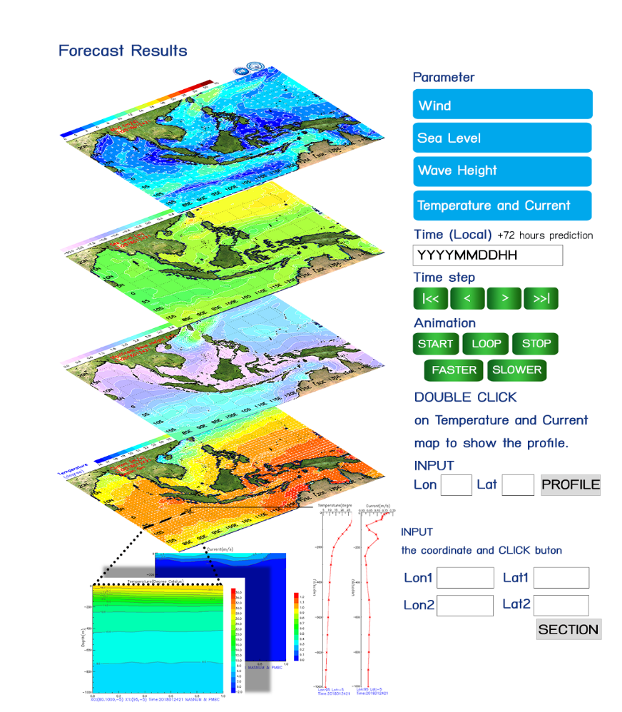
Figure 2 OFS visualization and tools for extracting specific results
During the past three years, there were many contributions from the OFS. For example, it was used as a boundary condition along the coast for sediment transport and coral dispersion model. Moreover, it was also used as one of the products acquired to monitor and forecast the next level of events like coral bleaching in 2016, sunken boat in Phuket due to heavy storm and strong surface wave in 2018 causing 47 missing, and Pabuk typhoon moving across the Gulf of Thailand to the Andaman Sea in 2019 inundating many coastal areas for a couple of weeks.
Considering the sunken ship case, both parties, Mr.Wannakiat Thubthimsang, Dr.Somkiat Khokiattiwong, and Prof. Fangli Qiao, had a serious discussion and energetically to give support by providing the forecasting products to those in charge. An emergency technical support team from FIO and PMBC was immediately established. Within 24h after the accident, the OFS team successfully provided the first forecasting report of surface currents, wave heights, and suggested search area for missing people. Totally 7 forecast reports were provided to the Thailand rescue team and forecasting results are confirmed by the following rescue, which is a new success for practical applications.
4. Establishing high resolution and its application
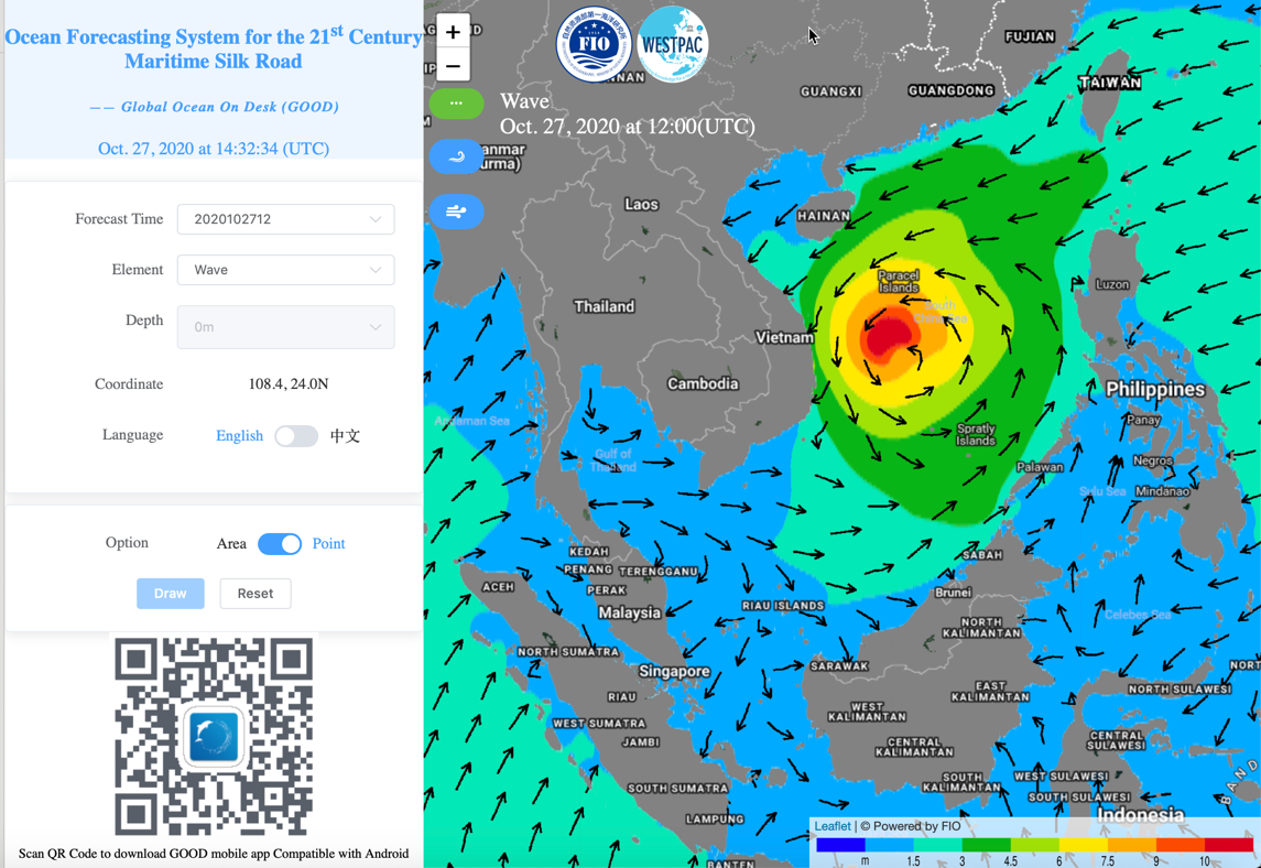
With OFS breakthroughs during the 2nd phase, the first surface wave-tide-circulation coupled model of FIO-COM was established in 2013, and then adopted as the core to produce a reanalysis dataset for the period Jan., 2014 to April, 2016. It became in the operational OFS since May, 2016. A highly efficient parallel scheme is designed to use the full-scale of Taihu-Light with 10,649,600 CPU cores (Qiao et al., 2016), which was on the finalist of the international ACM Gordon Bell Prize. The forecasting products can be easily accessed both through the website http://221.215.61.118:2018/#/ and the cell phone APP of “Global Ocean on Desk” (GOOD). To cite this dataset, please quote the version number and cite Qiao et al, (2019) (figure 3)
Figure 3 The snapshot of the OFS for 21st Century Maritime Silk Road published on 10 December 2018 through
Thailand now prepares for an extended basement to upgrade the new system in which the smallest grid will be re-fined down to less than 200 meters near the coasts. Including the simulation results, it is going to include tide and salinity which related to processes in mixed-layer depth and to the primary productivity and fisheries products. Visualization will also be upgraded to be more user-friendly, and the tracer module will be included in a new webpage for the prediction of floating in the sea.
Reference
Fan Y, Griffies S M, 2014. Impacts of parameterized Langmuir turbulence and nonbreaking wave mixing in global climate simulations. Journal of Climate, 27: 4752-4775, doi: 10.1175/JCLI-D-13-00583.1.
Lin X, Xie S P, Chen X, Xu L, 2006. A well-mixed warm water column in the central Bohai Sea in summer: Effects of tidal and surface wave mixing. Journal of Geophysical Research: Oceans, 111: C11017, doi:10.1029/2006JC003504.
Malek G, Babanin A V, 2014. Ocean mixing by wave orbital motion. Acta Physica Slovaca, 64(1): 1-56.
Péter T, Krámer T, 2016. Modeling the effect of waves on the diurnal temperature stratification of a shallow lake. Periodica Polytechnica Civil Engineering, doi: 10.3311/PPci.8883.
Qiao F, Yuan Y, Yang Y, Zheng Q, Xia C, Ma J, 2004. Wave-induced mixing in the upper ocean: Distribution and application in a global ocean circulation model. Geophysical Research Letters, 31: L11303, doi:10.1029/2004GL019824.
Qiao F, Yuan Y, Ezer T, Xia C, Yang Y, Lü X, Song Z, 2010. A three-dimensional surface wave-ocean circulation coupled model and its initial testing. Ocean Dynamics, 60(5): 1339-1355, doi: 10.1007/s10236-010-0326-y.
Qiao F, Zhao W, Yin X, Huang X, Liu X, Shu Q, Wang G, Song Z, Li X, Liu H, Yang G, Yuan Y, 2016. A highly effective global surface wave numerical simulation with ultra-high resolution. In Proceedings of the International Conference for High Performance Computing, Networking, Storage and Analysis (SC ‘16), IEEE Press, Piscataway, NJ, USA, Article 5, 46-56, ISBN 978-1-4673-8815-3.
Qiao F, Wang G, Somkiat Khokiattiwong, Mohd Fadzil Mohd Akhir, Zhu W, Xiao B, 2019. China published Ocean Forecasting System for the 21th Century Maritime Silk Road on 10 December, 2018. Acta Oceanologica Sinica, doi:10.1007/s13131-019-1365-y
Wu L, Rutgersson A, Sahlée E, 2015. Upper-ocean mixing due to surface gravity waves, Journal of Geophysical Research: Oceans, 120: 8210–8228, doi:10.1002/ 2015JC011329.
-
SCS:LEARN - Stories from the South China Sea(SCS)
Short Description -

SCS:LEARN - Stories from the SCS: Short Mackerel
Short Description -
SCS:LEARN - Stories from the SCS: Land-Based Pollution
Short Description -
SCS:LEARN - Stories from the SCS: Promoting Gender Equality in Fisheries
Short Description -

Short Film: SDG14 and the South China Sea
Short Description -

The South China Sea Fisheries Refugia Initiative
Short Description -

Fisheries Refugia Workshop
-

Larval Fish Training Workshop
-
Advanced Larval Fish Workshop